Google
Maps werd bedrogen door de Berlijnse kunstenaar Simon Wreckert, die
met een wagentje gevuld met 99 smartphones door straten van Berlijn
liep, waardoor Google Maps aangaf dat die straten vast waren gelopen met auto's, terwijl hij midden over
de weg liep en er geen auto was te zien (althans rijdend).....
Wreckert heeft e.e.a. gedaan om onder andere de mensheid te tonen hoeveel ruimte auto's innemen in ons dagelijkse leven.... Waarbij niet moet worden vergeten dat in Nederland ook nog eens 18.000 mensen jaren eerder overlijden na een akelige ziekte, alleen door langdurige inademing van auto-uitstoot, daarnaast loopt jaarlijks een groot aantal kinderen long- en/of luchtwegklachten op door diezelfde uitstoot.......
Voorts laat Wreckert zien dat we niet zomaar alle data moeten geloven, daar deze gemanipuleerd kunnen worden en daadwerkelijk worden gemanipuleerd, zo laat Google onwelgevallige informatie pas heel ver in de resultaten zien na een zoekopdracht, of toont deze informatie helemaal niet, anders gezegd: Google doet als Facebook zelfs aan censuur! (een populair instrument in dictatoriaal geregeerde landen.....)......
Met dank aan Gertjan van Beijnum, die een Twitterbericht besteedde aan het volgende artikel.
This Man Created Traffic Jams on Google Maps Using a Red Wagon Full of Phones
By pulling 99 phones down empty streets, artist Simon Wreckert made it look like they were gridlocked on Google Maps.
Feb
3 2020, 4:41pm
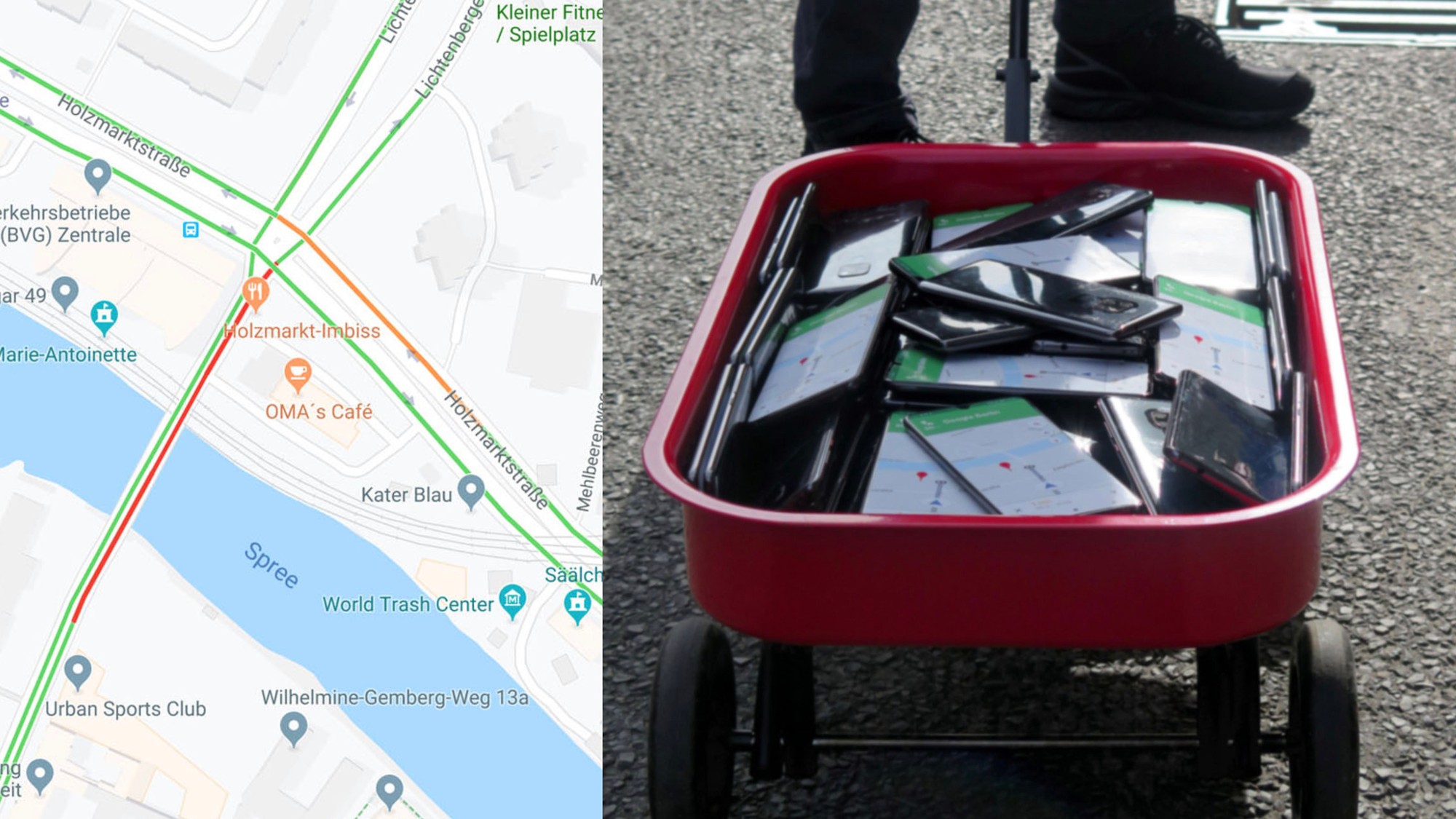
“By transporting the smartphones in the street I’m able to generate virtual traffic which will navigate cars on another route,” Wreckert told Motherboard in a Twitter DM. “Ironically that can generate a real traffic jam somewhere else in the city.”
Wreckert told Motherboard that he did the hack/art installation to get people to think about the space we give to cars in public life and the data we rely on everyday.
“Isn’t it crazy [how] much space is used by a car in a city compared to the usage?” he said.
“The hack shows us what is possible with this technology and who we rely on.”
To pull off the trick, Wreckert rented 99 smartphones, all of them Android devices, and purchased 99 sims cards for them online. He said he’d spend an hour or two on each spot, walking back and forth on the street to generate a traffic jam. “My subjective feeling was that even this short time was already enough to change the traffic in the street,” he said.
“‘The map is not the territory ... but another version of reality,’’ Wreckert said, quoting semanticist Alfred Korzybski, one of William S. Burroughs’ biggest influences. “Data is always translated to what they might be presented. The images, lists, graphs, and maps that represent those data are all interpretations, and there is no such thing as neutral data. Data is always collected for a specific purpose, by a combination of people, technology, money, commerce, and government.”
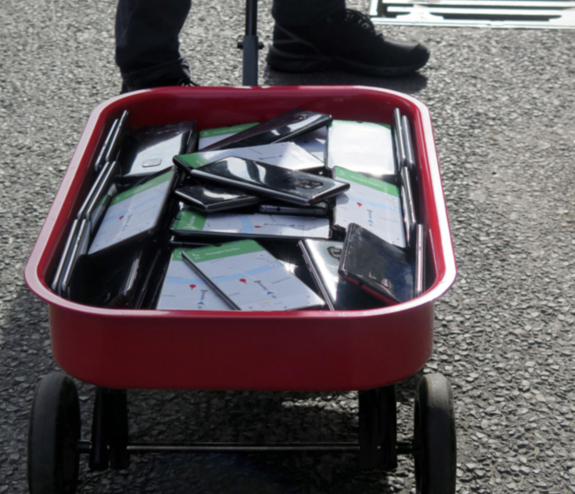
Image:
Simon Wreckert
The maps are their own territory,
their own objective reality, not just a reflection of the real world
but a branch of it. Wreckert was showing us all how data and maps can
affect the world they’re meant to chart. “Maps have the potential
as an instrument of power,” he said. “They substitute political and military power in a way that represents the state borders between territories and they can repeat, legitimate, and construct the differences of classes and social self-understandings.”
Data is not objective and the maps themselves have biases. Showing how the data can be hacked and manipulated is like pointing out the Emperor has no clothes.
“In this process it is pointing out the fact that we are highly focused on the data and tent to see them as objective, unambiguous, and interpretation free,” Wreckert said. “In doing so, a blindness arises against the processes that data generates and the assumption that numbers speak for themselves. Not only the collection of data provides an interpretative scope, but also computing processes allows further interpretations.”
“Thus data are viewed as the world itself, forgetting that the numbers are only representing a model of the world,” he said.
Coty Levandoski contributed reporting.
- Tagged:cars cities traffic maps infrastructure
Zie ook:
'Google Maps veegt Palestijns gebied van de kaart'
'Google helpt de farmaceutische industrie ten koste van alternatieve gezondheidsmedia'
'Grote internetplatforms als Facebook en Twitter weren in de VS anti-oorlog boodschappen en berichten, voorts worden giften geblokkeerd.....'
'Facebook keurde advertenties goed die waren gericht op neonazi's' (ja ja......)
'Facebook staat valse informatie toe tijdens de (voor-) verkiezingen van het presidentschap in de VS'
'Facebook censuur gestuurd door het westers militair-industrieel complex en de NAVO in het bijzonder..........'
'Why the Coordinated Alternative Media Purge Should Terrify Everyone' (van Zero Hedge)
'Facebook komt met nieuwsshows van betrouwbare media als CNN en Fox News.... ha! ha! ha! ha! ha! ha! ha!'
'Wie het nieuws controleert, controleert de wereld......'
'Facebook en Twitter verwijderen de eerlijke journalistiek en oprechte opinie >> censuur.....'
(zie ook de links in de bovenstaande berichten, anders dan deze hierboven getoonde berichten)
Voor (nog veel) meer berichten over manipulatie, censuur, Google, Twitter en Facebook, klik op het betreffende label, direct onder dit bericht (de laatste 2 genoemde internetplatforms doen ook aan censuur, terwijl Facebook wel leugens toestaat als het gaat om de voorverkiezingen in de VS en de presidentsverkiezingen zelf...... (waar Rusland op basis van geen enkel bewijs wordt beschuldigd van het manipuleren van verkiezingen.....)